Where to get ZIP code boundary files (free and trusted sources)
Searching for a ZIP code boundary map turns up dozens of downloads of unknown age. The short version: the U.S. Postal Service doesn't publish ZIP code polygons, and most free ZIP maps are built from the Census Bureau's ZIP Code Tabulation Areas. This guide lists the trusted sources, explains how they differ, and shows how to turn a national file into a KML you can map.
Quick answer
For free ZIP code boundaries in the United States, use the U.S. Census Bureau's ZIP Code Tabulation Areas (ZCTAs):
- Cartographic boundary files are simplified for mapping and available as shapefile or KML. Start here for territory maps.
- TIGER/Line shapefiles are the full-detail version, for precise GIS work.
- Gazetteer files aren't boundaries, but give each ZIP area an internal latitude and longitude for plotting ZIP codes as points.
Commercial ZIP datasets are worth paying for only when you need boundaries that track USPS changes more closely than the Census does.
Why there's no official ZIP code boundary map
A ZIP Code is a USPS delivery designation: a set of addresses served by a post office and its routes. The Postal Service doesn't publish ZIP Codes as polygons, and the routes change regularly. Some ZIP Codes cover a single building or only PO Boxes, so they have no meaningful area at all.
Every ZIP boundary map is therefore an approximation built by someone. The questions that matter are who built it, from what, and when.
Trusted sources for ZIP code boundaries
| Source | What you get | Format | Cost | Best for |
|---|---|---|---|---|
| Census cartographic boundary files: ZCTA | Simplified ZIP Code Tabulation Area polygons for the whole U.S. | Shapefile, KML | Free | Territory maps and web maps |
| Census TIGER/Line shapefiles: ZCTA | Full-detail ZCTA polygons that follow roads and streams closely | Shapefile, geodatabase | Free | Precise GIS analysis |
| Census Gazetteer files: ZCTA | One row per ZCTA with land area and an internal-point latitude and longitude | Pipe-delimited text | Free | Plotting ZIP codes as points; see plot ZIP codes on a map |
| HUD-USPS ZIP Code Crosswalk files | Tables linking ZIP Codes to counties, census tracts and metro areas, updated quarterly | Excel | Free account required | Assigning ZIPs to counties or regions; not shapes |
| Commercial ZIP boundary data | Boundaries derived from postal delivery data, often updated several times a year | Varies | Paid license | Routing, mail planning, frequent ZIP changes |
How to judge a ZIP boundary download
Free ZIP boundary files also circulate on GitHub, data portals and blogs, often converted to GeoJSON. Before you use one, check:
- Origin. Does it say it was built from Census ZCTAs or from postal data? No stated origin is a red flag.
- Vintage. Look for the year, such as 2020 ZCTAs. Files built from 2010 ZCTAs miss newer ZIP Codes.
- Resolution. Simplified files are lighter and fine for territories, but neighboring shapes may not share exact borders, which leaves slivers between ZIPs.
- Field names. A clear ZIP column, such as
ZCTA5CE20in 2020 Census files, makes matching and labeling easy. - License. Census files are public domain. Commercial and derived files have their own terms.
When in doubt, download directly from the Census Bureau. It takes the same few minutes and removes the guesswork.
Turn a national ZIP file into a KML for your area
Download the ZCTA file
From the Census Bureau's cartographic boundary files page, download the ZIP Code Tabulation Areas shapefile and unzip it. Keep all of the files that come with it; a shapefile is several files with the same name.
Open it in QGIS
QGIS is free for Windows, macOS and Linux. Choose Layer → Add Layer → Add Vector Layer and pick the
.shpfile.Select your ZIP codes
Use Select Features by Expression. For example,
"ZCTA5CE20" LIKE '80%'selects Colorado's 80xxx ZIPs, and"ZCTA5CE20" IN ('80202','80203')selects a list. You can also select by location with a state or county boundary.Export the selection as KML
Right-click the layer and choose Export → Save Selected Features As. Pick KML, set the name field to the ZIP column so each shape is named by its ZIP code, and save.
Import and check
In the TerritoryKit map builder, choose Import and add the KML. Each ZIP becomes a zone you can label, select and merge into territories.
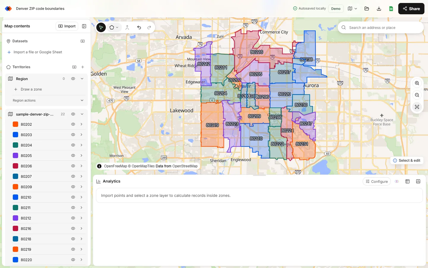
To practice without downloading the national file, use the 22 central Denver ZCTAs below. They come straight from the 2020 Census files at full resolution.
Which format should you choose?
| Format | Strengths | Watch out for |
|---|---|---|
| KML / KMZ | Opens in Google Earth and imports into TerritoryKit; KMZ is a zipped KML | Large national KML files are slow; export only your area |
| Shapefile | The standard Census format; best for GIS work | Several files per layer; most browser tools need conversion |
| GeoJSON | Popular for web maps and code | TerritoryKit imports KML or KMZ for boundaries, so convert GeoJSON in QGIS first |
More on the two Google formats is in KML vs KMZ for territory mapping.
What to do with ZIP boundaries next
- Build territories from ZIP codes by merging the ZIP areas each team owns. See how to create a territory map with ZIP codes.
- Check coverage by importing customer locations and counting how many fall in each ZIP, or outside every ZIP you serve.
- Plan delivery or service areas by ZIP; see delivery zone maps.
FAQ
Does the USPS publish ZIP code boundaries?
No. ZIP Codes are delivery routes and address lists, not official polygons. Free ZIP maps are usually built from the Census Bureau's ZIP Code Tabulation Areas; commercial vendors sell boundaries derived from postal data.
Where can I download a ZIP code KML file?
The Census Bureau's cartographic boundary files include ZIP Code Tabulation Areas in KML and shapefile formats. The national file is large, so filter it to your area in QGIS and export the selection as KML.
Are Census ZCTA boundaries accurate enough for sales territories?
Yes for most territory plans built from whole ZIP areas. They're approximate, so avoid them for mail delivery decisions, and check ZIPs that are new, PO Box-only or split between territories.
How often are ZIP code boundaries updated?
Census ZCTAs are revised with each decennial census, and the current set is from 2020. USPS changes ZIP Codes more often, so commercial datasets update several times a year.
Can I map multiple ZIP code boundaries at once?
Yes. Export all the ZIPs you need into one KML file and import it. Each ZIP becomes its own zone, and you can select several and merge them into a territory.
Related guides
Build your first territory map
Bring your account list, draw the territories you need, and see the results as the map changes. Your first map is free.
Open Map Builder