How to make a Europe sales territory map from built-in regions
European sales teams plan in each country's own units: départements in France, Kreise in Germany, provinces in Spain and Italy, gemeenten in the Netherlands. This guide shows what TerritoryKit has built in for each country, how to turn it into a Europe sales territory map, and where the limits are, including postcodes and cross-border territories.
Quick answer: a Europe sales territory map, country by country
To make a Europe sales territory map, open the TerritoryKit map builder and choose Territories → Add boundaries. Pick a country; France, Germany, Spain, Italy, the Netherlands, the UK and Ireland are in the Popular list. Under Territories from, choose the first level (regions, states or provinces) or the second level (departments, Kreise, provinces or municipalities), tick your areas and add them. Repeat for each country. Then select zones, choose Merge selected zones to build territories, and import your accounts to count them.
For territories made of whole countries, such as DACH, Benelux or the Nordics, choose World instead and pick countries. Adding boundaries needs no account.
What's built in for each European country
Every country in the picker has at least its first-level regions. The main European markets have a second level that works for field territories:
| Country | First level | Second level | Source |
|---|---|---|---|
| France | 18 regions | 101 departments | Natural Earth |
| Germany | 16 states | 401 districts (Kreise) | geoBoundaries, dl-de/by-2-0 |
| Spain | 52 provinces, with quick picks for 19 autonomous communities and cities | 8,205 municipalities | geoBoundaries, CC BY 4.0 |
| Italy | 20 regions | 110 provinces | Natural Earth |
| Netherlands | 12 provinces | 344 municipalities | geoBoundaries, CC0 |
| United Kingdom | 16 regions | 232 local authorities | Natural Earth; see the UK sales territory map guide |
| Ireland | 8 regions | 34 counties | Natural Earth |
| Austria | 9 states | 94 districts | geoBoundaries |
| Switzerland | 26 cantons | 169 districts | geoBoundaries |
| Belgium | 3 regions | 11 provinces | Natural Earth |
| Denmark | 5 regions | 98 municipalities | geoBoundaries |
| Norway | 19 counties | 426 municipalities | geoBoundaries |
| Sweden | 21 counties | 290 municipalities | geoBoundaries |
| Poland | 16 voivodeships | 380 counties (powiats) | geoBoundaries |
| Portugal | 20 districts | 309 municipalities | geoBoundaries |
| Czech Republic | 14 regions | 77 districts | geoBoundaries |
| Other countries | States, regions or counties | — | Natural Earth |
The picker shows each set's source and licence in its footer. Natural Earth data is public domain; geoBoundaries licences vary by country and some ask for attribution when you publish a map.
Notes for the main markets
France: departments
Departments are the classic building block of a French sales territory map. The picker lists 101, including the five overseas departments, which form their own regions. Names are shown without department numbers, so “Paris”, “Nord” and “Bouches-du-Rhône” rather than 75, 59 and 13; keep the numbers in your territory sheet. Search ignores accents, so rhone finds Rhône and Bouches-du-Rhône. A few names are in English, such as “French Guiana”.
Germany: Kreise
The 401 districts combine rural districts (Landkreise) and district-free cities (kreisfreie Städte). Where both share a name, the type is part of the name, such as “München, Kreisfreie Stadt” and “München, Landkreis”. Berlin and Hamburg are one zone each, and Bavaria alone has 96 districts. A Germany Kreise map is the most detailed German level built in; postcodes (PLZ) aren't included.
Spain: provinces and municipalities
Spain's first level is its 52 provinces, including Ceuta and Melilla. Quick-pick chips select whole autonomous communities, such as Andalucía, Cataluña or Madrid: at the provinces level a chip ticks the community's provinces, and at the municipalities level it ticks every municipality inside. With 8,205 municipalities (313 in Barcelona province alone), selections get large fast; the picker warns when a selection passes 1,500 areas. Build a Spain provinces map unless a territory really needs municipal detail.
Italy: provinces
The 110 provinces use English names such as Milan, Turin, Naples and Florence. They come from Natural Earth and follow an older layout in places: Sardinia shows its eight provinces from before the island's 2016 reorganisation. Merge zones if your plan follows the current provinces.
Netherlands: municipalities
The 344 municipalities (gemeenten) use official Dutch names, so search Gravenhage to find The Hague. Dutch municipalities merge most years, so compare the list with your current plan. Four-digit postcodes (PC4) aren't included.
Other European countries
Austria's 94 districts sit inside its nine states, and Switzerland's 169 districts inside its 26 cantons, which suits DACH field teams. Denmark, Norway and Sweden go down to municipalities, Poland to its 380 counties (powiats) and Portugal to 309 municipalities. Belgium has three regions and eleven provinces. Countries without a second level, such as Greece or Romania, have their regions or counties, which is usually enough for a distributor or country-manager map.
Build a territory map for one country
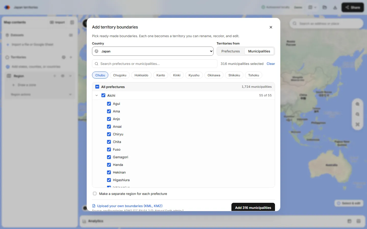
This example builds French sales territories from departments. The steps are the same for Kreise, provinces or municipalities.
Open the boundary library
In the map builder, choose Add boundaries (the globe button) in the Territories panel. The Add territory boundaries dialog opens.
Pick the country and level
Choose France from the Popular list. Under Territories from, choose Departments; choosing Regions instead adds the 18 regions as whole zones.
Select departments
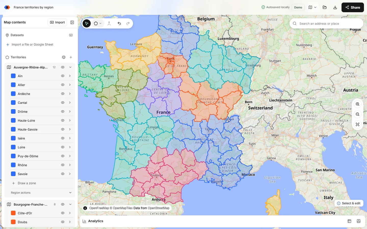
Tick a region such as Auvergne-Rhône-Alpes to select its 12 departments, then untick any you don't cover. Or search and use Select all matches.
Decide how to group them
Tick Make a separate region for each region to get one map region per French region, or leave it off for a single region. A territory's departments must be in the same region to merge. Choose Add.
Merge into territories
Ctrl-click (Cmd-click on a Mac) or Shift-click the departments for one territory and choose Merge selected zones. Rename it, for example “Sud-Est”, and recolor it. Use Line cut to split a department between two reps.
Add accounts and compare territories
Import a CSV or Excel file with latitude and longitude (see mapping CSV latitude and longitude). In Analytics, pick your accounts and the territories region to count accounts, total revenue with Measure → Sum of and list unassigned accounts.
Territories that cross borders
Many European teams cover more than one country. How you build that depends on the level:
- Whole countries. Choose World in the country list, which groups 242 countries by continent. Tick Germany, Austria and Switzerland, add them, and merge them into one “DACH” zone. The same works for Benelux, the Nordics or Iberia.
- Areas below country level. Add each country separately. Each add creates its own region, such as “France departments” and “Germany districts (Kreise)”. Merging works only within one region, so a territory covering Alsace and Baden stays as two zones in two regions. Give them the same name and color so they read as one territory. Analytics counts one region at a time, so add the two counts together.
For plans that reach beyond Europe, see international sales territory maps.
Postcodes in Europe aren't built in
Keep imported files small: export only the postcodes in your plan from QGIS. KML vs KMZ explains the two formats.
Tips for multi-country maps
- Use one region per country. Each country you add lands in its own region anyway. Keep it that way so counts, colors and names stay easy to follow.
- Name territories the same way everywhere. Use one naming pattern, such as “FR Sud-Est” or “DE Süd”, so a territory split across two countries is easy to spot in Analytics and exports.
- Keep each country's codes in your sheet. Zones are named after areas, not codes. Keep department numbers, district keys or province codes next to territory names for CRM rules.
- Expect mixed languages. Some names are local (“'s-Gravenhage”, “Bas-Rhin”) and some English (“Milan”, “Bavaria”). Search ignores accents and case, but not language.
- Start with the level you need. Regions and provinces load fast and are easy to merge. Add municipalities only where a territory truly needs them.
- Check unassigned accounts. Accounts outside every territory usually mean a missing area, a gap at a national border or wrong coordinates.
Accounts, exports and sharing
- Coordinates: TerritoryKit's address matching covers US addresses only, so European accounts need latitude and longitude from your CRM or a geocoding service.
- Assignments: the record table shows which territory each account falls in, and the point membership export (CSV or XLSX) hands that list to your CRM team.
- Exports: sign in to export a PNG or PDF (see exporting a territory map) or the zones as GeoJSON or KML. Free GeoJSON boundaries covers attribution for each source.
- Sharing: share the map with named viewers or editors for free. The Demo plan includes one owned map and 10 exports; Pro is US$19/month.
TerritoryKit doesn't balance territories automatically, plan routes, shade areas by a value or include demographic data. For the design side, see sales territory design.
FAQ
How do I make a sales territory map for Europe?
In TerritoryKit, choose Territories → Add boundaries, pick each country and its regions or second-level areas, and add them. Merge zones into territories and import accounts with coordinates to count them.
Is there a map of French departments I can edit?
Yes. Pick France and choose Departments to add any of the 101 departments, grouped by the 18 regions. Each department becomes an editable zone you can merge, rename and recolor.
Can I map German Kreise or postcodes (PLZ)?
Kreise, yes: the picker has 401 German districts grouped by state. German postcodes (PLZ) aren't built in; if you have licensed PLZ polygons, import them as KML.
Can I build territories from Spanish provinces or autonomous communities?
Yes. Spain has 52 provinces and 8,205 municipalities, with quick-pick chips for each autonomous community. Pick a community's provinces, add them, and merge them into a territory.
Can one territory cross a country border?
Yes for whole countries: pick them from the World set and merge them. Below country level, each country is its own region, so a cross-border territory stays as matching zones in two regions.
Are the European boundaries free to use?
Yes. They come from Natural Earth (public domain) and geoBoundaries (licence shown in the picker). Adding them is free; exports need a sign-in. See pricing.
Related guides
Build your first territory map
Bring your account list, draw the territories you need, and see the results as the map changes. Your first map is free.
Open Map Builder