How to make a UK sales territory map from regions and local authorities
UK teams often plan by region, county or council area, and many still remember building territories in Microsoft MapPoint. This guide shows how to make a UK sales territory map from the built-in regions and local authorities, why postcode areas aren't included, and how to bring your own postcode boundaries.
Quick answer: a UK sales territory map from built-in boundaries
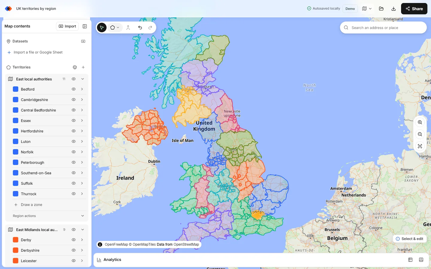
To make a UK sales territory map, open the TerritoryKit map builder and choose Territories → Add boundaries. Pick United Kingdom, then build from Regions (16) or Local authorities (232). Tick the areas you cover and add them. Each one becomes an editable zone named after the area. Select the zones for one territory, choose Merge selected zones, rename it and pick a color. Import your accounts to count them per territory.
UK postcode areas and districts aren't built in. If you've licensed postcode boundaries, import them as KML and merge them the same way. Adding built-in boundaries needs no account.
What's in the UK boundary set
The UK set comes from Natural Earth's admin-1 layer. England is split into its nine regions; Wales, Scotland and Northern Ireland are grouped as below. Choosing a region in the picker ticks every local authority inside it, and you can untick individual authorities afterwards.
| Region or nation | Local authorities | Examples |
|---|---|---|
| Greater London | 33 | Westminster, Camden, Croydon, Tower Hamlets |
| North West | 23 | Manchester, Liverpool, Lancashire, Cumbria |
| South East | 19 | Kent, Surrey, Hampshire, Brighton and Hove |
| South West | 16 | Bristol, Devon, Cornwall, Wiltshire |
| Yorkshire and the Humber | 15 | Leeds, Sheffield, North Yorkshire |
| West Midlands | 14 | Birmingham, Coventry, Staffordshire |
| North East | 12 | Newcastle upon Tyne, Sunderland, Durham |
| East | 11 | Norfolk, Essex, Cambridgeshire, Luton |
| East Midlands | 9 | Nottingham, Leicestershire, Lincolnshire |
| Wales (two statistical regions) | 22 | Cardiff, Swansea, Gwynedd, Powys |
| Scotland (four regions) | 32 | Glasgow, Edinburgh, Highland, Fife |
| Northern Ireland | 26 | Belfast, Derry, Lisburn, Newry and Mourne |
Build UK sales territories step by step
Open the map builder
Go to the map builder in a desktop browser on Windows, Mac, Linux or a Chromebook. You can start as a guest.
Open the boundary library
In the Territories panel, choose Add boundaries (the globe button). The Add territory boundaries dialog opens.
Pick United Kingdom and a level
Choose United Kingdom from the Popular list. Under Territories from, choose Regions for 16 large zones or Local authorities for 232 smaller ones.
Select your areas
Tick a region to select all its local authorities, then untick any you don't cover. Or type in Search boundaries:
lanarkfinds North and South Lanarkshire, and Select all matches ticks both.Choose how the areas are grouped
Everything goes into one region on the map unless you tick Make a separate region for each region, which keeps, for example, the North West and Yorkshire in separate regions. Merging only works within one region, so put a territory's authorities in the same one. Then choose Add.
Merge areas into territories
Ctrl-click (Cmd-click on a Mac) or Shift-click the authorities for one territory and choose Merge selected zones. Rename the result, such as “Scotland Central”, and recolor it. To split a large authority such as Highland or North Yorkshire, select it and use Line cut along a road or river.
Add accounts and check balance
Import a CSV or Excel file with latitude and longitude (see mapping CSV latitude and longitude). In Analytics, pick the accounts and the territories region to see counts, revenue totals with Measure → Sum of, and unassigned accounts.
Why UK postcode areas and districts aren't built in
A UK postcode has four levels: the area (SW), the district (SW1A), the sector (SW1A 1) and the unit (SW1A 1AA), which covers a handful of addresses.
Postcodes are managed by Royal Mail as lists of delivery addresses, not as published shapes. Postcode boundary polygons are built from that address data by data companies and sold under licence. The free postcode boundary files that circulate online are often out of date or unclear about their licence, so TerritoryKit doesn't ship them. Local authorities are the open alternative: every part of the UK is covered, and the boundaries change rarely.
Import your own postcode boundaries as KML
If your company has licensed postcode district or sector boundaries, you can use them:
- Check the licence. Make sure it allows use in third-party web tools and sharing with your team.
- Cut the file down. Open it in QGIS, keep the districts in your plan, and export the selection as KML with the district code as the name field. A national sector file is large and slow in any browser map.
- Import it. In the Add territory boundaries dialog, choose Upload your own boundaries (KML, KMZ), or use Import. Each polygon becomes a zone named after its district.
- Merge districts into territories. Imported zones form their own region, so merge them there, not with the local authority zones.
More on the two Google formats is in KML vs KMZ for territory mapping. Without postcode polygons, you can still draw territories on the map around clusters of accounts.
For account locations, free postcode lookup files such as the ONS Postcode Directory give a latitude and longitude for each postcode. Join them to your account list in Excel and import the result. TerritoryKit's own address matching covers US addresses only.
Local authorities, regions or postcodes?
| Building block | In TerritoryKit | Use it when | Watch out for |
|---|---|---|---|
| Regions | Built in (16) | Regional managers, distributors, national overviews | Too coarse for field reps; London is one region |
| Local authorities | Built in (232) | Field teams, public sector contracts, council-based reporting | Large rural councils; some boundaries predate recent reorganisations |
| Postcode districts or sectors | Import your own KML | CRM routing by postcode and dense urban territories | Licensed data; files get large at sector level |
| Drawn territories | Draw tools | Custom areas around clusters of accounts | Harder to turn into CRM rules |
Tips for UK territory maps
- Split London deliberately. Greater London has 33 authorities, including the City of London, listed as “London”. Most plans split it into inner and outer, or north and south of the Thames, by merging boroughs.
- Watch the very large councils. Highland, North Yorkshire and Cornwall are each one zone. Use Line cut if one rep can't cover the whole area, and note the road you followed.
- Keep a council-to-territory sheet. After merging, a territory is one shape and no longer lists its authorities. Keep the list as the record for CRM rules and contracts.
- Rename merged zones at once. A merged zone is named after the first area you selected plus “merged”. Rename it to the territory name your team uses.
- Check unassigned accounts. Analytics lists accounts outside every territory, which usually means a missing authority or a coordinate in the sea.
Replacing MapPoint for UK territory maps
Microsoft stopped selling MapPoint on December 31, 2014, and it no longer receives map updates. TerritoryKit covers the territory side of what MapPoint did: shapes from built-in or imported boundaries, accounts plotted from coordinates, and counts and totals per territory. It runs in the browser, so it also works on a Mac. It doesn't do route planning, drive-time areas or automatic territory balancing. See the MapPoint alternative guide for a job-by-job comparison and recreating MapPoint territories for moving an old plan across.
Old MapPoint plans usually survive as a spreadsheet of postcode districts or counties per rep. If the list is by county or council, rebuild it from the built-in local authorities and merge them per rep. If it's by postcode district, either import licensed district boundaries as KML or translate each district to the council it mostly falls in, accepting that some lines will move. Either way, check the new map against your account list before you send it to the team.
Share, export and expand beyond the UK
Share the map with named viewers or editors for free, present it in presentation mode, or sign in to export a PNG or PDF (see exporting a territory map). Zones also export as GeoJSON or KML for a GIS team; free GeoJSON boundaries covers the formats and the attribution each source needs. The free Demo plan includes one owned map and 10 exports; Pro is US$19/month.
The Republic of Ireland is a separate country in the picker, with 8 regions and 34 counties. For territories that continue into Europe, see the Europe sales territory map guide, and for a worldwide plan see international sales territory maps.
FAQ
How do I make a sales territory map for the UK?
Open the TerritoryKit map builder, choose Territories → Add boundaries, pick United Kingdom and select regions or local authorities. Merge the areas for each territory, then import accounts with coordinates to count them.
Can I map UK postcode areas or districts in TerritoryKit?
Not from the built-in library. UK postcode boundaries are licensed data, so they aren't included. If you've licensed postcode district or sector polygons, convert them to KML and import them.
Is there a free UK local authority map?
Yes. TerritoryKit includes 232 UK local authorities in 16 regions from Natural Earth, free to add in guest mode. For the latest council boundaries, the ONS Open Geography Portal publishes them under the Open Government Licence.
What is a good MapPoint alternative in the UK?
For territory maps, a browser tool such as TerritoryKit builds territories from UK local authorities or imported boundaries. For routing, you need a separate route planner. See the MapPoint alternative guide.
Can I put my UK customers on the map by postcode?
Yes, as points. Add a latitude and longitude for each postcode, for example from the ONS Postcode Directory, and import the file. TerritoryKit doesn't geocode UK addresses itself.
Does the UK map include Northern Ireland and Scotland?
Yes. The UK set covers England, Wales, Scotland and Northern Ireland. Northern Ireland appears as its 26 former districts, which you can merge to approximate today's 11 councils.
Related guides
Build your first territory map
Bring your account list, draw the territories you need, and see the results as the map changes. Your first map is free.
Open Map Builder