Best territory mapping software in 2026: an honest buyer's guide
Search for territory mapping software and every vendor list puts its own product first. This guide sorts the options into six categories instead, says what each is genuinely good at, and is plain about where TerritoryKit, the tool we make, is the wrong choice.
Quick answer: the best territory mapping software by job
There is no single best territory mapping software; there is a best fit for the job you need done. In short:
- Shade states or counties by territory in a report: Excel map charts, if you already have Microsoft 365.
- Share a quick map of a few hand-drawn areas: Google My Maps.
- Run full spatial analysis with your own data: desktop GIS such as QGIS, which is free.
- Optimize territories automatically, plan routes or use bundled demographics: a desktop territory tool such as Maptitude, or a specialist platform.
- Keep assignments inside your CRM: a CRM-embedded territory tool, such as Salesforce Maps for Salesforce.
- Build territories from real boundaries and count accounts in each, with no install: a browser territory map maker such as TerritoryKit.
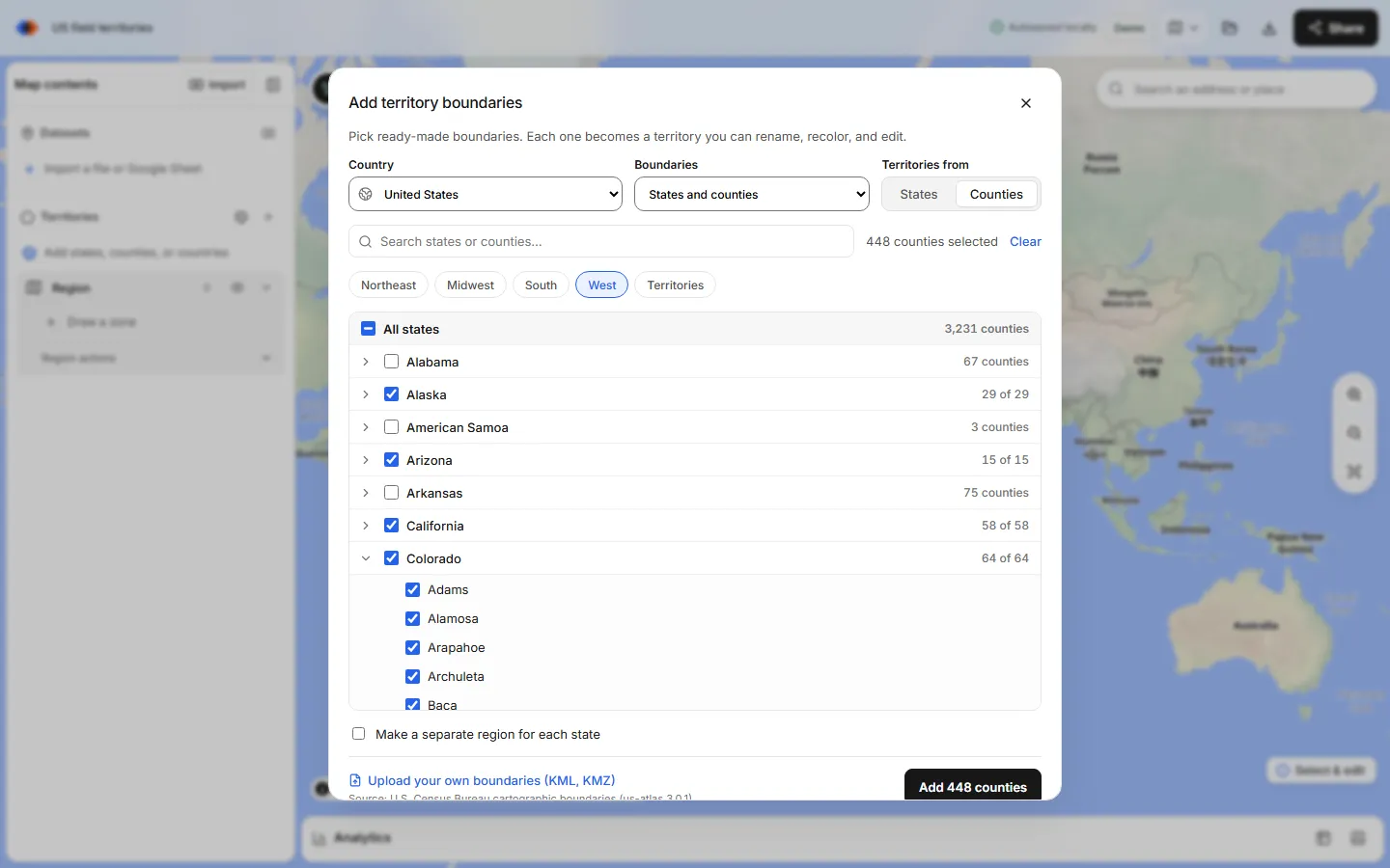
TerritoryKit is a browser-based territory map maker that turns spreadsheets and built-in boundaries for about 215 countries into editable sales territories, then counts the accounts in each one.
What to look for in a sales territory mapping tool
Judge every option against the same criteria. The ones that matter most for territory planning:
- Boundaries. Can you build territories from states, counties, ZIP codes or postal areas without sourcing files yourself?
- Data import. Does it read your CSV or Excel file as-is? Does it place street addresses, or need latitude and longitude?
- Counts per territory. Does it tell you how many accounts, and how much revenue, fall in each territory, and which accounts fall in none or two?
- Editing. Can you merge, split and reshape territories without starting over?
- Automation. Does it balance territories, plan routes or calculate drive times?
- Sharing and exports. Can colleagues open the live map? Can you get PNG, PDF, CSV and boundary files out?
- Setup and platform. Install or browser, Windows only or Mac too, and how long until the first useful map.
Territory mapping software compared by category
| Category | Best for | Install | Built-in boundaries | Counts per territory | Balancing, routing |
|---|---|---|---|---|---|
| Excel map charts | Shading regions by a territory column | Excel (Microsoft 365) | Countries, states, counties, postal codes recognized by name | No | No |
| Google My Maps | Quick shared maps from addresses | Browser | No | No | No |
| Desktop GIS (QGIS) | Full analysis, any data, custom cartography | Desktop: Windows, macOS, Linux | No; you download them | Yes, with processing tools | Possible with plugins and effort |
| Desktop territory tools (e.g. Maptitude) | Territory design with bundled data | Desktop installer | Typically yes | Yes | Varies by product; check the vendor |
| CRM-embedded tools (e.g. Salesforce Maps) | Territories that drive CRM ownership | Inside the CRM | Varies by product | Yes, on CRM records | Varies by product; check the vendor |
| Browser territory makers (e.g. TerritoryKit) | Boundary-based territories with counts, no install | Browser | Yes: about 215 countries, ZIP3, FSA, postcodes | Yes | No |
The six categories, honestly
Excel map charts
Excel's filled map chart, part of Microsoft 365, colors countries, states, counties or postal codes from a column of names and a value or category. Put a territory name next to each county and Excel shades the plan. Microsoft documents the limits: map charts show high-level geography only, so they can't plot latitude and longitude points or street addresses, and you can't draw custom boundaries or count accounts per territory. Good for a slide; not for planning. More in sales territory mapping in Excel.
Google My Maps
My Maps is free with a Google account, places rows by address and shares like a Google Doc. Its documented limits are 2,000 rows per imported file and per layer, 10 layers and 10,000 features per map. It has no count of places inside each shape, no overlap report and no territory column written back to your data. See territory maps in Google Maps.
Desktop GIS such as QGIS
QGIS is free, open-source GIS for Windows, macOS and Linux. It can do almost anything: count points in polygons, join census tables, reproject, and export every common format. The cost is time. You source and filter boundaries yourself, and non-GIS colleagues usually get exported images rather than the live project.
Desktop territory tools such as Maptitude
MapPoint, Microsoft's Windows mapping program, was discontinued at the end of 2014, and many former users moved to desktop territory tools. Maptitude, from Caliper, is a Windows desktop mapping program with territory-building tools and bundled geographic and demographic data. Tools in this category tend to be the deepest for territory design; check each vendor's current feature list for balancing, routing and drive-time areas, and its licence terms. The MapPoint alternatives guide maps each old MapPoint job to a current tool.
CRM-embedded territory tools
If ownership lives in your CRM, a tool inside it avoids exports and re-imports. Salesforce Maps, an add-on for Salesforce, works on CRM records directly; Salesforce's Enterprise Territory Management assigns accounts by rules rather than on a map. These suit teams already standardized on that CRM and willing to buy the add-on licence.
Browser territory map makers such as TerritoryKit
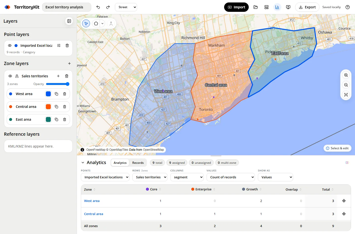
Browser tools sit between My Maps and GIS: no install, but real territory features. TerritoryKit can add US counties, 3-digit ZIP areas, Canadian postal FSAs, Australian postcodes and the states or districts of about 215 countries as editable territories, without uploading a file. It imports CSV, Excel, KML, KMZ and Google Sheets, counts and sums accounts per territory in Analytics, and flags accounts in two territories or none.
Where TerritoryKit is strong, and where other tools are better
| Need | TerritoryKit | Better choice if this is essential |
|---|---|---|
| Start in minutes, no install | Yes. Runs in a desktop browser on Windows, Mac, Linux and Chromebook; guest editing needs no account | TerritoryKit covers it |
| Territories from real boundaries | Yes. Countries, states, counties, districts, US ZIP3 and 5-digit ZIP lookup, Canadian FSAs, Australian postcodes; see the ZIP code map maker guide | QGIS or a desktop tool for UK postcodes, German PLZ or Dutch PC4, which are not included |
| Counts, sums and gaps per territory | Yes, with overlaps and unassigned records | TerritoryKit covers it |
| Export boundaries and results | PNG, print/PDF, CSV, Excel, GeoJSON, KML, project backup | TerritoryKit covers it |
| Sharing with the team | Free named viewers, editors and admins on every plan; saved revisions, not live co-editing | A CRM tool if everyone works in the CRM |
| Automatic balancing or optimization | No. You adjust borders while watching the counts | Desktop or specialist territory tools |
| Route planning and drive-time areas | No | A route planner or desktop territory tool |
| CRM sync (Salesforce, HubSpot) | No. Export point membership instead | CRM-embedded tools |
| Demographic data and value shading | No demographics, no heat maps or choropleth shading by a numeric value | QGIS or a desktop tool with bundled data |
| Address geocoding | Up to 1,000 US addresses per import via the Census geocoder; no international geocoding | A commercial geocoder for rooftop or international accuracy |
Which should you choose?
- You manage 3 to 30 territories from a spreadsheet and want counts per rep this week: start with a browser territory map maker. Open the map builder and try one region.
- You need territories balanced automatically across 50 reps, or daily routes: shortlist desktop or specialist territory tools and ask for a trial on your own data.
- Your CRM is the system of record and admins maintain ownership rules there: evaluate your CRM's own territory add-on first.
- You have a GIS analyst and need demographics, custom projections or unusual data: QGIS.
- You only need a picture for a board deck: Excel map charts or My Maps will do.
- You plan across countries: check boundary coverage first; the international sales territory map guide shows what a mixed country-and-state plan looks like.
Budget is often the deciding factor for small teams. The free territory mapping software comparison covers what you get at no cost, and the free GeoJSON boundaries guide covers getting boundary files for other tools.
How to evaluate territory planning software in an afternoon
List the jobs, not the features
Write down what the map must answer: who owns this account, is the workload even, which ZIP codes are unassigned. Mark anything that must be automatic.
Prepare a test file
Export a few hundred real accounts with an ID, a value column such as revenue, and coordinates or US street addresses. Keep the current owner column for comparison.
Build one region in two tools
Recreate one existing territory set from counties or ZIP codes in each shortlisted tool. Time how long it takes from sign-up to a usable map.
Check the numbers
Compare each tool's count and revenue per territory with your spreadsheet. Look at accounts in no territory and in two; they reveal boundary or data problems.
Test the hand-off
Export what your team will use: a PDF for managers, an account list with territories for the CRM, boundary files for analysts. Share the map with one colleague.
Price the real setup
Count seats, viewers and add-ons. Check whether sharing is charged per user and whether exports or maps are capped on the plan you would buy.
A pilot like this shows more than any feature grid, including this one. If a tool can't reproduce one known region accurately, it won't handle the whole plan.
FAQ
What is the best territory mapping software for small sales teams?
For a handful of reps and a spreadsheet of accounts, a browser territory map maker such as TerritoryKit is usually quickest: no install, built-in boundaries and counts per territory, with a free Demo plan.
Which territory mapping software balances territories automatically?
Automatic balancing is found in some desktop and specialist territory tools and CRM add-ons; check each vendor's documentation. TerritoryKit doesn't balance territories automatically; you adjust borders while watching the counts.
Is there free territory mapping software?
Yes. QGIS and Google My Maps are free, and TerritoryKit lets you build maps as a guest with a free Demo account for saving and 10 exports. See the free territory mapping software comparison.
What replaced Microsoft MapPoint for territory mapping?
MapPoint was discontinued at the end of 2014. Former users moved to desktop territory tools such as Maptitude, desktop GIS such as QGIS, or browser tools such as TerritoryKit, depending on which MapPoint jobs they relied on.
Does TerritoryKit integrate with Salesforce or HubSpot?
No. TerritoryKit doesn't sync with a CRM. Export point membership as CSV or Excel to update account owners, or use a CRM-embedded territory tool if live sync is essential.
How much does TerritoryKit cost?
The Demo plan is free with one owned map and 10 exports. Pro costs US$19 per month or US$190 per year, with unlimited maps and exports. Sharing with named viewers and editors is free on both.
Related guides
Build your first territory map
Bring your account list, draw the territories you need, and see the results as the map changes. Your first map is free.
Open Map Builder