ZIP code map maker: paste ZIP codes, get a boundary map
Most people looking for a ZIP code map maker already have the list. What they want is to paste it somewhere and see those ZIP areas shaded on a map, not a pin per code. This guide shows the fastest way to do that in a browser, how to handle lists longer than 50 codes, and how to turn the result into labeled areas you can share or export.
Quick answer: make a ZIP code map in about a minute
TerritoryKit works as a free ZIP code map maker in any desktop browser. Open the map builder, choose Territories → Add boundaries, set the country to United States and the boundaries to 5-digit ZIPs or FIPS codes (look up). Paste up to 50 ZIP codes, select Preview boundaries, then Add boundaries to map. Each ZIP code appears as a shaded area that you can recolor, label, merge with its neighbors and export.
- No account needed to build the map. Guest editing is free, and adding boundaries doesn't require sign-in.
- Up to 50 ZIP codes per lookup. Run the lookup again for longer lists, or switch to 3-digit ZIP areas for state-wide and national maps.
- Sign in to export. PNG, print/PDF, GeoJSON and KML exports need a free account. The Demo plan includes 10 exports in total.
What a ZIP code map maker should show: areas or points
A ZIP code map can mean two different pictures. An area map shades the shape of each ZIP code, which answers “which ZIP codes do we cover?” A point map puts a dot at each ZIP or each customer, which answers “where are they?” This guide is about areas. If a dot per ZIP is enough, plot ZIP codes on a map covers point methods, including Excel and Google My Maps. If you are building sales territories and assigning accounts, create a territory map with ZIP codes goes deeper on ZIP-to-territory sheets.
TerritoryKit gives you four ways to get ZIP areas, or points, onto a map. Pick by the size of your list and how fine the map needs to be.
| Method | What you get | Limit | Best for |
|---|---|---|---|
| 5-digit ZIP lookup | One shaded area per ZIP code, from 2020 Census ZIP Code Tabulation Areas | 50 ZIP codes per lookup | Local maps: a store's delivery area, a rep's ZIP list, a service area |
| 3-digit ZIP areas | 896 areas, each covering the ZIP codes that share their first three digits | Coarser than 5-digit ZIPs | State-wide, regional and national maps |
| Upload KML or KMZ | Any ZIP boundary file you prepared yourself, for example in QGIS | You download and filter the file | Hundreds of 5-digit ZIPs that must sit in one region |
| Points from a spreadsheet | One dot per row from latitude and longitude, or from matched US street addresses | Address matching: 1,000 US addresses per import | Customers, jobs or leads on top of the ZIP areas |
What the built-in ZIP boundaries are
A USPS ZIP Code is a set of delivery addresses, not an official shape. To map ZIP codes as areas, TerritoryKit's lookup uses the U.S. Census Bureau's 2020 ZIP Code Tabulation Areas (ZCTAs), fetched from Census TIGERweb. A ZCTA is an approximate area for a ZIP code, built from census blocks. Most residential ZIP codes have one. PO Box-only ZIPs and some business ZIPs don't, because they have no land area of their own.
That makes the map right for planning and presentation: coverage, rep areas, delivery zones, a slide for a meeting. It isn't an official postal delivery boundary, and it shouldn't decide which ZIP a specific address mails to. The ZIP code boundary files guide explains ZCTAs and other sources in more detail.
Step by step: create a map with multiple ZIP codes
Clean up the ZIP list
Keep ZIP codes as text so leading zeros survive: 02108, not 2108. Cut ZIP+4 codes to their first five digits. Separate codes with commas or new lines; the lookup keeps the leading zeros you paste.
Open the ZIP lookup
In the map builder, open the Territories panel and choose Add boundaries, the globe button. In the Add territory boundaries dialog, pick United States, then 5-digit ZIPs or FIPS codes (look up) under Boundaries. Keep ZIP areas (ZCTAs) as the boundary type.
Paste and preview
Paste up to 50 codes into the ZIP codes box and select Preview boundaries. The preview lists every ZIP area found. Codes without a Census ZCTA appear under “No boundary found for”. Fix any typos, or check Continue with found areas only to go on without them.
Choose one territory or one zone per ZIP
Type a Territory or layer name. Turn on Combine selected areas into one territory when the whole list is one area, such as a store's delivery zone; ZIPs that don't touch still count as one territory. Leave it off to get one zone per ZIP code, named by its ZIP, which you can group later.
Add the boundaries
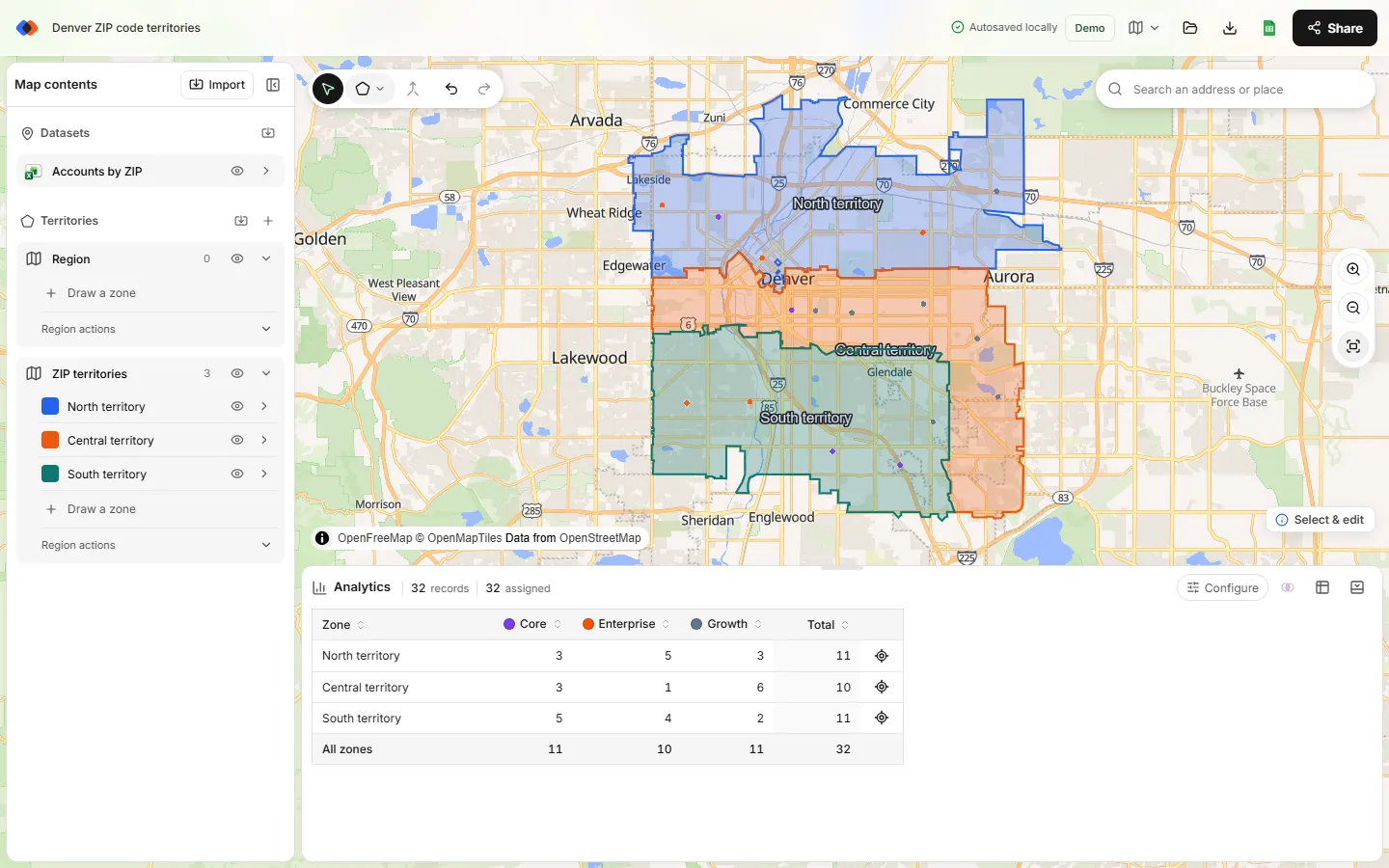
Select Add boundaries to map, then Fit all data to zoom to them. The ZIP areas arrive as a new region in the Territories panel, each in its own color.
Merge ZIPs into larger areas
With the select tool, Ctrl-click (Cmd-click on a Mac) or Shift-click the ZIP zones that belong together, then choose Merge selected zones. Shared borders disappear. Rename the result, pick a color and repeat for each group.
How to map more than 50 ZIP codes
The 50-code limit applies to each lookup, not to the map. Paste the next 50 and repeat. Before you do, know one rule: each lookup adds its own region, and Merge selected zones only joins zones inside the same region. So plan your batches around what you want to merge.
- One batch per territory. If each territory has 50 ZIP codes or fewer, run one lookup per territory with Combine turned on and name it after the territory. Five territories, five lookups.
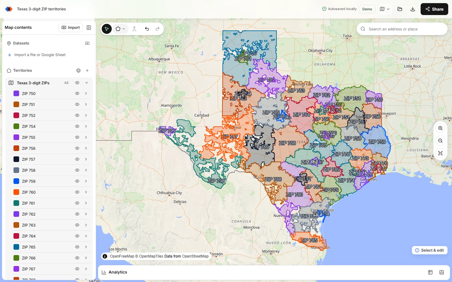
- 3-digit ZIP areas for big maps. If your areas follow ZIP prefixes, use the 3-digit ZIP codes boundary set instead. It has no 50-code limit: check a whole state or a Census region at once and every prefix lands in one region. See how to make a 3-digit ZIP code map.
- A KML file for hundreds of 5-digit ZIPs. Filter the Census ZCTA file to your list in QGIS, export the selection as KML and use Upload your own boundaries (KML, KMZ). Every ZIP arrives in one region, so any of them can be merged.
Highlight ZIP codes on a map with your own data
Shaded ZIP areas get more useful with something on top. Import a CSV, an Excel file or a Google Sheet into the same map. Rows with latitude and longitude plot directly. Rows with US street addresses can be matched during import: choose Find coordinates from addresses, and up to 1,000 US addresses per import are matched by the US Census geocoder. Exact matches are selected automatically, other matches need your review, and unmatched rows can't be plotted. Addresses to latitude and longitude covers other options.
Then open Analytics, pick your data under Dataset and your ZIP region under Territories. TerritoryKit counts the points inside each ZIP area or merged area, breaks them down by a category such as segment, and totals a number column with Measure → Sum of. Points outside every ZIP area show up as unassigned, which is a quick way to spot a ZIP missing from your list.
One thing TerritoryKit doesn't do is shade ZIP codes automatically by a number, like a heat map where darker ZIPs mean higher sales. You choose each area's color. For value-shaded maps, an Excel filled map chart or a GIS tool such as QGIS is the better fit.
Label, share and export your ZIP code map
- Labels and legend. Show zone names on the map and add a legend so readers know which color is which. See add labels and a legend.
- Presentation mode hides the editing tools for a meeting or a screen share.
- Sharing with named viewers, editors or admins is free on both plans. Changes are saved as revisions; there's no simultaneous live editing.
- Images and documents. Export a PNG or print to PDF for slides and handouts. Export a territory map as PNG or PDF has the details.
- Boundary files. Export the ZIP areas as GeoJSON or KML to reuse them in another tool. Free GeoJSON boundaries explains the formats and attribution.
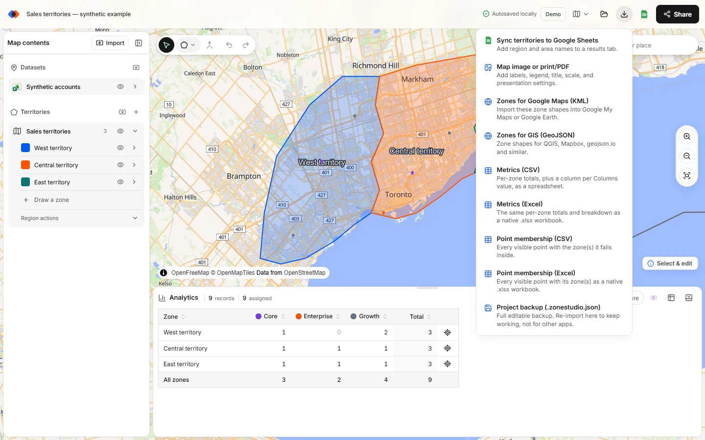
Exports need sign-in. The Demo plan includes one owned map and 10 exports in total. Pro costs US$19 a month or US$190 a year for unlimited maps and exports; see pricing.
Limits to know before you start
- 50 ZIP codes per lookup. There's no browsable list of all 5-digit ZIPs; longer lists take several lookups, 3-digit areas or a KML file.
- Approximate shapes. ZCTAs are from the 2020 Census and simplified for planning. They aren't survey-grade or official delivery boundaries, so check accounts that sit right on a border.
- Merging stays inside a region. Zones from different lookups can't be merged together, and merged ZIPs that don't touch become separate pieces named “… merged 1”, “… merged 2”.
- Splitting a ZIP is possible with Line cut: select the zone, draw a line across it and press Enter.
- US only for ZIPs and address matching. Other countries have their own boundary sets, such as Canadian postal FSAs and Australian postcodes, but no address matching.
FAQ
Is there a free ZIP code map maker?
Yes. TerritoryKit lets you paste up to 50 ZIP codes, see their Census boundaries and merge them into areas without an account. Exporting an image or file needs a free sign-in, and the Demo plan includes 10 exports. See pricing.
How do I create a map with multiple ZIP codes?
Choose Territories → Add boundaries, pick United States and 5-digit ZIPs or FIPS codes (look up), paste your ZIP codes separated by commas or new lines, preview them and add them to the map. Each ZIP becomes its own shaded zone, or one combined territory.
How many ZIP codes can I map at once?
Up to 50 per lookup, and you can run as many lookups as you need. For whole states or the whole country, the 3-digit ZIP set adds hundreds of prefix areas at once; see the 3-digit ZIP code map guide.
Can I enter ZIP codes to create a map without coordinates?
Yes. The ZIP lookup takes plain ZIP codes and returns their boundaries. You only need coordinates, or US street addresses to match, when you want to plot individual customers on top.
Why are some of my ZIP codes missing from the map?
The lookup uses 2020 Census ZIP Code Tabulation Areas. PO Box-only ZIPs, some business ZIPs and ZIPs created after 2020 have no ZCTA, so they have no shape. The preview lists them before you add anything.
Can I color ZIP codes by sales, like a heat map?
Not automatically. TerritoryKit colors each zone individually and counts or sums your data per area in Analytics, but it doesn't shade areas by a numeric value. Use an Excel filled map chart or QGIS for value shading.
Related guides
Build your first territory map
Bring your account list, draw the territories you need, and see the results as the map changes. Your first map is free.
Open Map Builder