How to make a Canada postal code map with FSA boundaries
Canadian teams usually route leads and assign reps by the first three characters of a postal code. This guide shows how to turn those forward sortation areas into a Canada postal code map you can edit, when census divisions are the better building block, and what to do with large rural FSAs.
Quick answer: a Canada postal code map in a few minutes
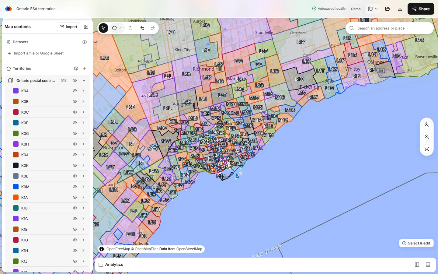
A Canada postal code map for sales territories is built from forward sortation areas (FSAs), the first three characters of a postal code, such as M5V. In the TerritoryKit map builder, open Territories → Add boundaries, choose Canada, set Boundaries to Postal codes (FSA), tick the FSAs you want and add them. Each FSA becomes an editable zone named after its code. Select several and choose Merge selected zones to make a territory, then import your accounts to count them per territory.
Adding boundaries works in guest mode with no account. The FSA boundaries come from Statistics Canada's 2021 boundary files under the Statistics Canada Open Licence and are simplified for planning. They aren't Canada Post's official delivery boundaries, and there are no boundaries for full six-character postal codes.
What an FSA is, and why maps stop at three characters
A Canadian postal code has six characters in the pattern letter, digit, letter, space, digit, letter, digit. The first half is the forward sortation area; the second half is the local delivery unit (LDU).
- The first letter is a postal district: one province, or part of a large province. Ontario uses K, L, M, N and P; Quebec uses G, H and J.
- A 0 as the second character marks a rural FSA. The picker has 181 of them, and they are often very large.
- The LDU narrows the code to one side of a street, a single large building or a rural route. Areas that small change often and aren't published as boundaries, so a forward sortation area map is the finest postal level you can build territories from.
Statistics Canada's 2021 file lists 1,643 FSAs, and the picker shows all of them, grouped by province and territory:
| Province or territory | First letters | FSAs in the picker |
|---|---|---|
| Ontario | K, L, M, N, P | 520 |
| Quebec | G, H, J | 414 |
| British Columbia | V | 191 |
| Alberta | T | 154 |
| New Brunswick | E | 110 |
| Nova Scotia | B | 77 |
| Manitoba | R | 74 |
| Saskatchewan | S | 52 |
| Newfoundland and Labrador | A | 35 |
| Prince Edward Island | C | 7 |
| Yukon, Northwest Territories, Nunavut | Y, X | 3 each |
Build Canadian sales territories from FSAs
Open the map builder
Go to the map builder. You can start as a guest; sign in later if you want to save to the cloud or export.
Open the boundary library
In the Territories panel, choose Add boundaries (the globe button). The Add territory boundaries dialog opens.
Choose Canada and Postal codes (FSA)
Pick Canada from the Popular list, then set Boundaries to Postal codes (FSA). Under Territories from, keep Postal code areas (FSA) selected; the other button adds whole provinces instead.
Select the FSAs you need
Tick a province to select every FSA in it, then untick the ones you don't cover. To pick a city, type in Search boundaries:
M5lists the 14 central Toronto FSAs from M5A to M5V. Choose Select all matches to tick them in one go. Search matches anywhere in the code, so check the list before adding.Choose one region or one per province
By default every FSA goes into one region named after the province, such as “Ontario postal code areas (FSA)”. Tick Make a separate region for each province if you're adding several provinces and want each one in its own region. Then choose Add.
Merge FSAs into territories
Ctrl-click (Cmd-click on a Mac) or Shift-click the FSAs for one territory and choose Merge selected zones. Rename the result, for example “Toronto Downtown”, and pick a color. Merging works within one region, so keep a territory's FSAs in the same region.
Add your accounts and count them
Import a CSV or Excel file with latitude and longitude columns (see mapping CSV latitude and longitude). Open Analytics, choose your accounts as the dataset and your FSA region as the territories, and you get a count per territory, totals for numeric columns with Measure → Sum of, and a list of unassigned accounts.
FSAs or census divisions?
Canada has a second boundary set in the picker: Provinces and census divisions. Census divisions are Statistics Canada's county-like areas, 293 in total. In Ontario they include Toronto, Peel, York, Durham, Halton and Ottawa; Quebec's follow its regional county municipalities; Alberta, Saskatchewan and Manitoba number theirs, such as Division No. 6.
| Building block | Areas | Use it when | Watch out for |
|---|---|---|---|
| Provinces and territories | 13 | Regional managers, distributors or a national overview | Too coarse for field reps; Ontario and Quebec usually need splitting |
| Census divisions | 293 | Rural and regional field teams, or contracts written by region or county | CRMs rarely route leads by census division, so keep a lookup sheet |
| Postal FSAs | 1,643 | Urban teams and lead routing by postal code prefix | Rural FSAs are huge; FSA lines don't follow municipal boundaries |
| Full postal codes | Not available as areas | Assigning individual accounts | Plot accounts as points and assign them by FSA instead |
Pick one building block per map. FSAs and census divisions overlap, so mixing them in one plan creates double coverage. A common pattern is a national map of provinces for managers and a separate FSA map for each metro team. The same choice comes up south of the border, where 3-digit ZIP code areas are the closest match to FSAs.
Large rural FSAs
An urban FSA might cover a few blocks of downtown Toronto. A rural one can cover a large part of a province: Nunavut and Yukon have three FSAs each. On a Canada FSA map, those big shapes dominate the view and can hold accounts that belong to different reps.
If most of a territory is rural, census divisions often give cleaner lines. Read more about the trade-offs in sales territory design.
Working with full six-character postal codes
Your CRM probably stores full postal codes such as M5V 1A1. You can still use them:
- Plot accounts as points. Add latitude and longitude to each account and import the file. TerritoryKit's address matching covers US addresses only, so Canadian coordinates need to come from your CRM or another geocoding service.
- Add an FSA column. In Excel,
=LEFT(A2,3)turns a postal code into its FSA. Your territory rules can then match zone names exactly. - Export assignments. The record table adds a membership column for each territory, and the point membership export (CSV or XLSX) lists the territory each account falls in. See assigning accounts to territories.
Tips for a clean FSA territory map
- Name territories after the plan, not the first FSA. A merged zone is named after the first FSA you selected plus “merged”, so rename it straight away to the name your reps and CRM use.
- Add only the provinces you cover. All 1,643 FSAs at once passes the picker's large-selection warning at 1,500 areas, and big maps are slower to edit and save. Add a province at a time, with a separate region for each.
- Keep an FSA list per territory. After merging, a territory is a single shape and no longer lists its FSAs. Keep an FSA-to-territory sheet as the record for CRM routing rules.
- Check unassigned accounts. Analytics lists accounts outside every territory. They usually point to an FSA you forgot or a postal code typed with the wrong first letter.
- Review accounts near FSA lines. The boundaries are simplified, so an account on a border street can land on the wrong side. Check the few that matter by hand.
- Plan cross-border teams on one map. Canadian FSAs and US ZIP areas can sit on the same map, but each set you add becomes its own region, and merging works within a region. A territory covering Ontario and Michigan is two zones with the same name and color.
Share and export the map
Present the map in presentation mode, or sign in to export it as PNG or print it to PDF (see exporting a territory map). You can also export the zones as GeoJSON or KML for a GIS tool or a developer; free GeoJSON boundaries covers that route and the attribution each source needs. The free Demo plan includes one owned map and 10 exports in total; Pro is US$19/month. Sharing with named viewers and editors is free on both.
Covering more than Canada? FSAs, US ZIP areas and other countries' regions can sit on one map; see international sales territory maps.
Data source and limits
- Source: Statistics Canada 2021 cartographic boundary files, Statistics Canada Open Licence. The picker shows the source in its footer.
- Accuracy: simplified for planning, not survey-grade. Check accounts close to FSA lines.
- Vintage: Canada Post adds and retires postal codes over time, so a 2021 boundary may not match a brand-new FSA.
- Not included: boundaries for full postal codes, heat maps by value, automatic territory balancing and route planning.
FAQ
Is there a map of Canadian postal codes?
Yes, at the forward sortation area level. Statistics Canada publishes FSA boundaries, and TerritoryKit includes them under Territories → Add boundaries → Canada → Postal codes (FSA), grouped by province.
What is an FSA in a Canadian postal code?
The forward sortation area is the first three characters of a postal code, such as M5V. The first letter is a postal district, and a 0 as the second character means a rural FSA.
Can I map full six-character postal codes as areas?
No. Boundaries for full postal codes aren't published, and TerritoryKit doesn't include them. Plot accounts as points with latitude and longitude, and assign them to territories built from FSAs.
How many FSAs are there in Canada?
Statistics Canada's 2021 boundary file lists 1,643 forward sortation areas, and the TerritoryKit picker shows all of them. Ontario has the most, with 520.
Should I use FSAs or census divisions for Canadian sales territories?
Use FSAs for urban teams and when your CRM routes leads by postal code. Use census divisions (293 areas) for rural or regional teams that want cleaner, larger building blocks.
Can I create Canadian sales territories for free?
Yes. Adding FSA boundaries, merging them and counting accounts works in guest mode. Exports need a sign-in; the free Demo plan includes 10 exports. See pricing.
Related guides
Build your first territory map
Bring your account list, draw the territories you need, and see the results as the map changes. Your first map is free.
Open Map Builder