How to make an Australia postcode map for sales territories
Australian sales, service and delivery teams often split the country by postcode. This guide shows how to build an Australia postcode map from the Australian Bureau of Statistics' postal areas, how those areas differ from Australia Post postcodes, and when local government areas are the better choice.
Quick answer: an Australia postcode map in a few minutes
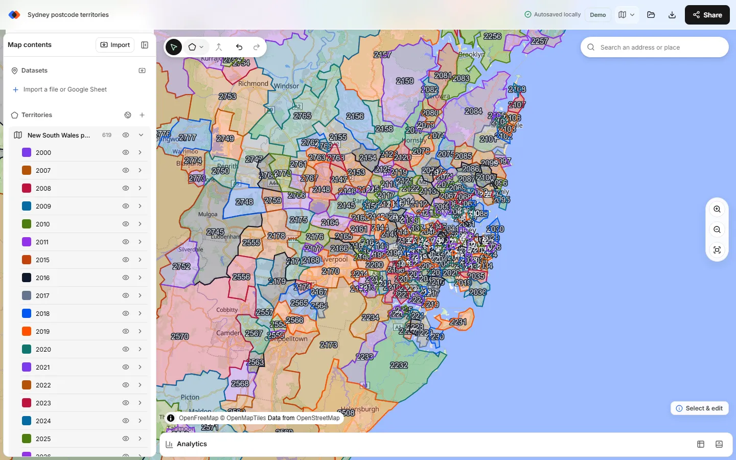
To make an Australia postcode map, open the TerritoryKit map builder, choose Territories → Add boundaries, pick Australia and set Boundaries to Postcodes. Tick the postcodes you need, by state or with the search box, and add them. Each postcode becomes an editable zone named after its four digits. Select the postcodes for one territory and choose Merge selected zones, then import your accounts to count them per territory.
The picker has 2,641 postcode boundaries from the ABS Australian Statistical Geography Standard (ASGS) 2021 postal areas, licensed CC BY 4.0. Adding them needs no account. If your territories follow council areas instead, switch Boundaries to States and local government areas for 547 LGAs.
Postal areas vs Australia Post postcodes
A postal area (POA) is the Australian Bureau of Statistics' approximation of a postcode, built from small statistical areas so that census data can be reported by postcode. It is close to the postcode on the envelope but not identical:
- Approximate edges. Postal areas follow statistical building blocks, so their edges don't exactly match Australia Post's delivery areas. They are planning boundaries, not official delivery boundaries.
- No PO box postcodes. Postcodes used only for PO boxes or large organisations have no area. That's why the picker's New South Wales list jumps from 2000 to 2007.
- Border postcodes appear once. A postcode that crosses a state border is listed under one state. For example, 2620, which spans the NSW–ACT border around Queanbeyan, is listed under New South Wales.
For sales territories, service areas and lead routing by whole postcodes, postal areas are accurate enough. For delivery promises at the street level, check addresses close to postcode edges.
| State or territory | Postcodes start with | Postcodes in the picker |
|---|---|---|
| Victoria | 3 | 692 |
| New South Wales | 2 | 619 |
| Queensland | 4 | 431 |
| Western Australia | 6 | 386 |
| South Australia | 5 | 341 |
| Tasmania | 7 | 115 |
| Northern Territory | 08 | 34 |
| Australian Capital Territory | 26 and 29 | 23 |
Build sales territories by postcode
Open the map builder
Go to the map builder. Guest editing works without an account; sign in when you want to save to the cloud or export.
Open the boundary library
In the Territories panel, choose Add boundaries (the globe button) to open Add territory boundaries.
Choose Australia and Postcodes
Pick Australia from the Popular list and set Boundaries to Postcodes. Under Territories from, keep Postcodes selected; the other option adds whole states.
Select postcodes
Tick a state to select every postcode in it, then untick the ones outside your plan. Or type in Search boundaries and choose Select all matches. Search matches digits anywhere in the code, so
200finds 2000, 2007, 2008 and 2009 but also 2200 and 3200; untick the extras before adding.Add them as one region or one per state
Everything you tick goes into one region unless you tick Make a separate region for each state. A territory you plan to merge must sit in a single region, so keep cross-border plans in one region. Then choose Add.
Merge postcodes into territories
Ctrl-click (Cmd-click on a Mac) or Shift-click the postcodes for one territory, choose Merge selected zones, then rename and recolor the territory. Repeat for each rep, branch or franchise.
Import accounts and check coverage
Import a CSV or Excel file with latitude and longitude (see mapping CSV latitude and longitude). In Analytics, choose the accounts and the postcode region to count accounts per territory, sum a revenue column with Measure → Sum of, and see accounts outside every territory.
Postcodes or local government areas?
The second Australian boundary set has 547 local government areas (LGAs), the areas of local councils such as Blacktown, Parramatta, Brisbane, Gold Coast and Moreton Bay. Names that repeat across states carry the state, such as “Bayside (NSW)”. An LGA map suits teams whose contracts, permits or reporting follow councils.
| Building block | Areas | Use it when | Watch out for |
|---|---|---|---|
| States and territories | 8 plus external territories | National managers, distributors and state-based reporting | Too coarse for field reps in Sydney, Melbourne or Brisbane |
| Local government areas | 547 | Council contracts, local marketing, and regional or rural reps | Metro councils can be large and dense; rural LGAs can be vast |
| Postcodes | 2,641 | Sales territories by postcode, lead routing and delivery areas | More areas to manage; edges are approximate; PO box postcodes have no area |
Three questions usually settle the choice. How does your CRM route leads? If it assigns by postcode, build from postcodes so the map and the rules match. Do contracts, tenders or permits name councils? Then LGAs keep the map in the same language as the paperwork. Do reps cover regional and remote areas? LGAs there are fewer and simpler, while metro teams often need the finer grain of postcodes. If the answers differ by team, make a separate map for each team rather than mixing the two sets.
Choose one building block per map and stick to it. Mixing postcodes and LGAs creates overlaps that are hard to explain to reps.
Very large regional postcodes
In the cities a postcode may be a few suburbs. In regional Australia it can be enormous: 0872 in the Northern Territory covers a vast area of central Australia. One big postcode can hold accounts that belong to two reps or two branches.
Keep postcode territories usable outside the map
- Keep a postcode list. After merging, a territory is a single shape and no longer lists its postcodes. Keep a postcode-to-territory sheet for CRM rules and contracts.
- Add the territory to each account. The record table shows a membership column for every territory, and the point membership export (CSV or XLSX) gives your CRM team the result. See assigning accounts to territories.
- Get coordinates first. TerritoryKit matches US street addresses only, so Australian accounts need latitude and longitude from your CRM or a geocoding service before import.
- Plan delivery areas the same way. Postcode zones work for service and delivery areas too; see delivery zone maps.
Tips for postcode territories
- Add one state at a time. All 2,641 postcodes at once passes the picker's large-selection warning at 1,500 areas and makes the map slower to edit and save. For a national plan, add each state with Make a separate region for each state, or use LGAs outside the capital cities on a separate map.
- Rename merged territories straight away. A merged zone is named after the first postcode you selected plus “merged”. Rename it to the territory name your CRM uses, such as “Sydney North Shore”.
- Label the map for reviews. Territory names and a legend make a postcode map readable in a meeting; see labels and legends.
- Check unassigned accounts. Analytics lists accounts outside every territory. They usually mean a missing postcode, a PO box postcode with no area, or coordinates in the wrong place.
- Review accounts near postcode edges. Boundaries are simplified for planning, so an account on a border street can fall on the wrong side. Check the ones that matter by hand.
Share and export
Show the map in presentation mode, share it with named viewers or editors for free, or sign in to export it as PNG or PDF; exporting a territory map walks through the options. You can also export the zones as GeoJSON or KML; free GeoJSON boundaries explains the formats and the CC BY 4.0 attribution the ABS data needs. The Demo plan is free with one owned map and 10 exports in total.
Planning beyond Australia? The same picker covers New Zealand's 88 territorial authorities and Canada's postal FSAs; see the Canada postal code map guide and international sales territory maps.
Data sources and limits
- Postcodes: ABS ASGS 2021 postal areas, CC BY 4.0. Approximations of Australia Post postcodes, simplified for planning.
- LGAs: geoBoundaries ADM2 (CC BY 4.0) with Natural Earth states. Council amalgamations can make a boundary out of date, so compare names with your own list.
- Not included: suburb boundaries, heat maps by value, automatic territory balancing, route planning and Australian address geocoding.
FAQ
Is there a free Australia postcode boundary map?
Yes. The ABS publishes postal area boundaries under CC BY 4.0, and TerritoryKit includes all 2,641 under Territories → Add boundaries → Australia → Postcodes, ready to group into territories.
Are ABS postal areas the same as Australia Post postcodes?
Not exactly. Postal areas are ABS approximations of postcodes built from statistical areas. They are close enough for sales territories, but they aren't official delivery boundaries and PO box postcodes have no area.
How do I create sales territories by postcode in Australia?
Add the postcodes for your area from the boundary library, select the postcodes for each territory, choose Merge selected zones and rename it. Then import accounts with coordinates to count them per territory.
Can I make an LGA map instead of a postcode map?
Yes. Set Boundaries to “States and local government areas” and choose local government areas. The picker has 547 LGAs grouped by state, and each becomes an editable zone.
Why can't I find some postcodes in the picker?
Postcodes used only for PO boxes or large organisations have no ABS postal area, so they don't appear. A postcode that crosses a state border is listed under one state only.
Can I export Australian postcode boundaries?
Yes. Sign in and export the zones as GeoJSON or KML. On the free Demo plan each export counts toward the 10 included. See pricing.
Related guides
Build your first territory map
Bring your account list, draw the territories you need, and see the results as the map changes. Your first map is free.
Open Map Builder