Create sales territories from Excel
This guide shows how to create sales territories from Excel when your spreadsheet already has location rows and coordinate columns.
Example: turn an Excel account list into a territory map
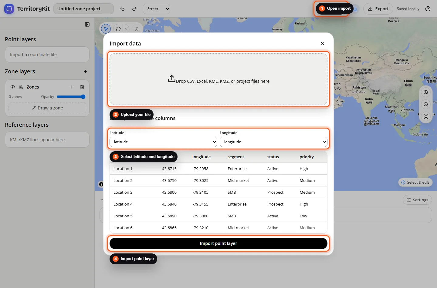
The workbook needs one location per row and numeric latitude and longitude. The downloadable example contains synthetic Toronto-area locations with segment, status, and priority fields. Replace these with your own coordinate-ready records before using the result for planning.
| location_name | latitude | longitude | segment | status |
|---|---|---|---|---|
| Location 1 | 43.6715 | -79.2958 | Enterprise | Active |
| Location 2 | 43.6750 | -79.3025 | Mid-market | Active |
| Location 3 | 43.6800 | -79.3105 | SMB | Prospect |
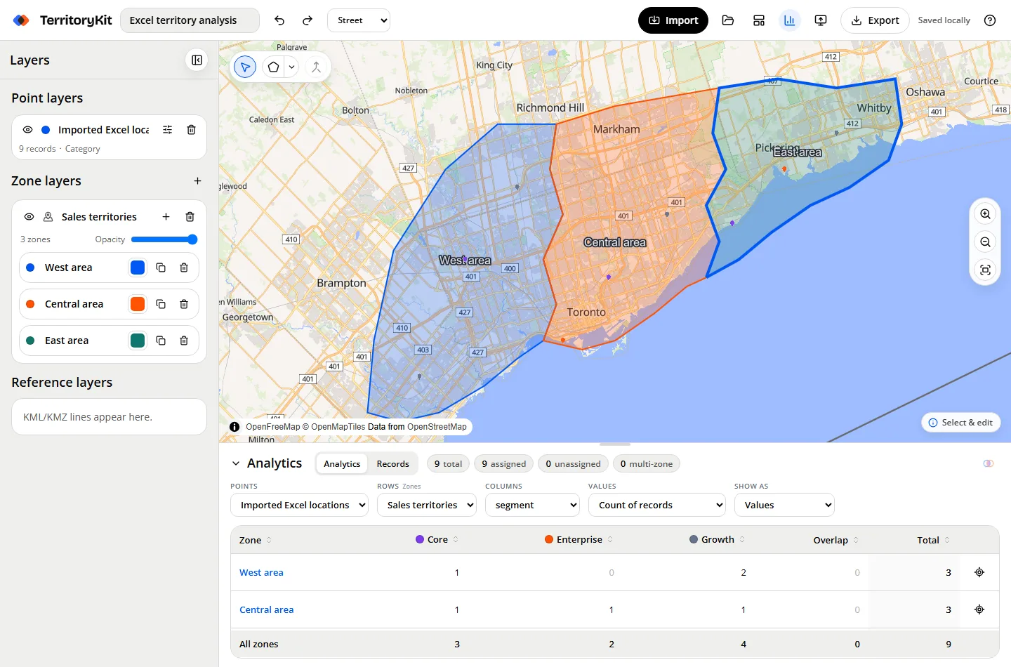
After importing, draw a territory around a few locations. In Analytics, select the imported point layer and your zone layer, then group by segment to compare Enterprise, Mid-market, and SMB counts. Move one boundary and confirm that the affected count changes.
Validate assignments before sharing
Suppose a test dataset has 10 locations: 4 belong only to East, 3 only to West, 2 to both, and 1 to neither. East shows 6 and West shows 5. Their sum is 11, but only 9 unique locations are covered. Export point membership to inspect overlapping assignments and the unassigned location. TerritoryKit reports membership; it does not choose a sales owner for a conflict.
Record counts also do not measure revenue or workload. Keep your account IDs and planning fields in the workbook, then use the exported membership table for additional Excel analysis. For the column checklist and file choices, see the sales territory map template guide.
When to use this
Use this workflow when your customer, prospect, account, branch, or site list is in an Excel workbook and you want to turn it into an editable territory map without GIS software.
Step-by-step workflow
Prepare the workbook
Keep one location per row. Use clear headers such as
location_name,latitude,longitude,segment, andstatus. The current builder needs latitude and longitude columns for spreadsheet points.Open the map builder
Use the TerritoryKit map builder, or start with the synthetic sales territory template to explore the finished workflow first.
Import the Excel file
Choose Import, upload an XLSX or XLS file, then select the latitude and longitude columns. Review valid, repaired, skipped and invalid row counts before creating the point layer.
Verify the mapped points
Check that the point layer appears in the left panel and that the points land where you expect. If records are missing, check the coordinate columns and empty rows.
Draw or import the territories
Use the polygon or circle drawing tools for custom sales territories. You can also import existing KML or KMZ boundaries if your team already has territory shapes.
Check counts and overlaps
Open the analytics panel, select the point layer and zone layer, and review totals, unassigned records, and records that fall in more than one zone.
Export the results
Use Export to download metrics, point membership, territory geometry, or a portable project backup for later editing.
Supported formats and inputs
- Excel point data: XLSX and XLS files with usable latitude and longitude columns.
- Other imports confirmed by the app: CSV, KML, KMZ, JSON, and .zonestudio.json project files.
- Territory geometry can be drawn in the browser or imported from KML/KMZ files.
- The current product does not geocode street addresses, balance territories automatically, optimize routes, or forecast revenue.
Tips and common mistakes
- Missing latitude or longitude values are skipped during spreadsheet import.
- Latitude must be between -90 and 90, and longitude must be between -180 and 180.
- Separate coordinate columns are simplest, but the repair assistant can also split clear values such as
43.67,-79.32from one column. - Remove blank rows and make headers clear before importing. Duplicate headers can make the preview harder to read.
- If the map looks empty, use Fit all data and confirm the selected coordinates are not reversed.
Export and results
TerritoryKit can export per-zone metrics as CSV or Excel, point-to-territory membership as CSV or Excel, zone geometry as GeoJSON or KML, and a portable .zonestudio.json project backup.
FAQ
Can TerritoryKit create a sales territory map from Excel?
Yes, when the Excel file has latitude and longitude columns for each location row.
Can I use addresses instead of coordinates?
No. The current version does not geocode addresses. Add coordinates before importing the spreadsheet.
Does TerritoryKit automatically balance sales territories?
No. You draw or import the territories. TerritoryKit shows counts, overlaps, and exports so you can evaluate the plan.
Can I keep working later?
Yes. Meaningful edits autosave in the current browser profile. Export a project backup before changing devices or clearing site data.
Can I export Excel results?
Yes. Metrics and point membership can be exported as native Excel workbooks or CSV files.
Related workflows
Build your first territory map
Bring your coordinates, draw the zones you need, and see the results as the map changes.
Open Map Builder